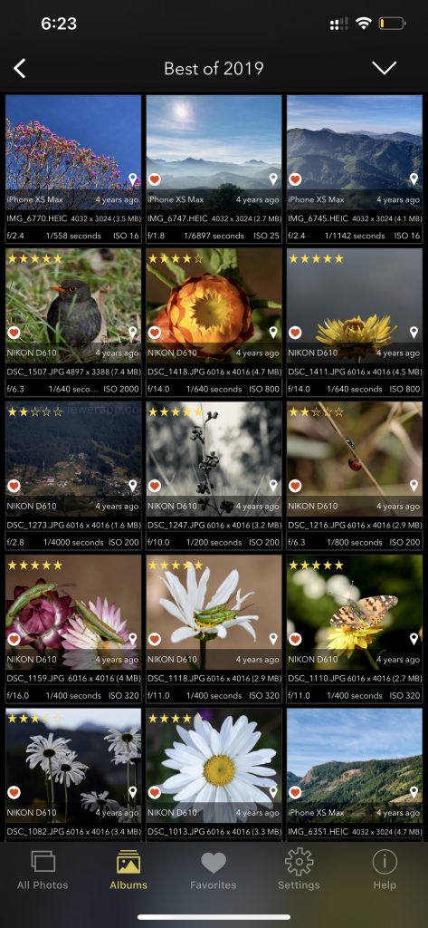
In the world of digital imagery, precision and credibility are paramount. Geotagging and EXIF metadata integration, along with the innovative EXIF Viewer by Fluntro app, stand out as vital tools, revolutionizing the way location information is stored and utilized within digital images. Let’s delve into how this powerful integration, coupled with the cutting-edge features of the EXIF Viewer by Fluntro app, enhances the accuracy and reliability of location information, providing valuable context and trustworthiness for various applications.
Geotagging: An Introduction to Location Precision
Geotagging, the process of assigning geographical coordinates to digital media, is a game-changer for photo enthusiasts, globetrotters, and professionals seeking to capture the precise essence of their surroundings. By incorporating latitude and longitude coordinates, geotagging transforms images into veritable storytellers, narrating the tale of their origin with unmatched accuracy.
EXIF Metadata: The Backbone of Image Context
While geotagging ensures pinpoint location accuracy, EXIF metadata serves as the backbone of image context. Through the Exchangeable Image File Format (EXIF), a wealth of critical data including camera settings, date and time, aperture, and more, is stored within digital images. This information, when amalgamated with geotagging, crafts a comprehensive narrative, painting a vivid picture of the circumstances surrounding each capture.
The EXIF Viewer by Fluntro App: Unveiling a World of Data Insights
In the pursuit of unparalleled user experience and data accessibility, the EXIF Viewer by Fluntro iOS app emerges as a pioneering solution. With its user-friendly interface and powerful capabilities, the app unlocks the hidden treasure trove of EXIF metadata, enabling users to effortlessly access and interpret critical image information. From camera specifications to location details, the EXIF Viewer app empowers users to delve deep into the intricacies of each digital image, fostering a deeper understanding and appreciation of the captured moments.
Appstore Link: – https://apps.apple.com/us/app/exif-viewer-by-fluntro/id944118456
- Visit the App Store on your iPhone or iPad.
- Search for “EXIF viewer by Fluntro“.
- Download and install the app. EXIF Viewer app allows you to view image metadata.

EXIF Viewer by Fluntro App Screenshot showing Images all exif details using including lens, geotagging, DPI. For more details scroll down.
Precision Redefined: The Power of Enhanced Contextual Information
The integration of geotagging, EXIF metadata, and the EXIF Viewer by Fluntro app not only offers enhanced contextual information but also infuses each image with an unparalleled level of credibility. Whether for journalistic endeavors, travel documentation, or forensic investigations, the integrated data lends a newfound depth to the image, bolstering its credibility and trustworthiness.
Unwavering Reliability: Upholding Data Integrity
By ensuring the seamless integration of geotagging, EXIF metadata, and the EXIF Viewer by Fluntro app, the integrity and reliability of location information within digital images receive an unprecedented boost. This integration serves as a safeguard against errors or discrepancies, ensuring the consistency and dependability of the associated data. As a result, misrepresentations and manipulations of location-related details become a thing of the past.
Uniting Technology: GIS Integration and Beyond
The integration of geotagging, EXIF metadata, transcends individual images, seamlessly integrating into Geographic Information Systems (GIS) and other technological frameworks. This integration facilitates the creation of comprehensive spatial databases and maps, empowering professionals in diverse fields such as urban planning, environmental science, and geology to harness precise geographical data for their analytical pursuits.
Personalization Redefined: Fueling Location-Based Services (LBS)
Geotagging, EXIF metadata integration pave the way for a new era of personalized experiences through location-based services (LBS). Whether in the realms of location-based advertising, social networking, or personalized content delivery, the precise location information associated with images facilitates the seamless delivery of tailored and contextually relevant services, ensuring a truly personalized digital experience.
Geotagging, EXIF metadata integration, and the innovative EXIF Viewer by Fluntro app herald a new era of precision and reliability in the digital imagery landscape. Empowering various applications, these technologies not only enhance the accuracy of location information but also redefine the way we interact with and interpret digital imagery. Embrace this seamless integration, along with the power of the EXIF Viewer by Fluntro app, to unlock a world of untapped possibilities and ensure that your digital footprint leaves an indelible mark of credibility and precision.
RELATED TOPICS:
– WHAT IS GEOTAGGING IN PHOTOGRAPHY?
– HOW TO TURN ON OR OFF PHOTO GEOTAGGING ON YOUR IPHONE OR IPAD
– HOW TO VIEW GPS LOCATION COORDINATES OF PHOTOS ON IPHONE OR IPAD?
– EXIF DATA: WHAT IT REVEALS ABOUT YOUR PHOTOS
–HOW TO ADD GEOTAGS TO PHOTOS ?
– HOW TO FIX IPHONE PHOTOS NOT SHOWING LOCATION?
– METADATA IN PHOTO EDITING: ALTERATION IN EXIF DATA
Checkout the preview video of Exif Viewer by Fluntro: